
Filtered by:
- Sale Section
4 items
- List
- Grid
A subscription to the Price Guide is required to view results for auctions ten days or older. Click here for more information


Lot 438
CARY'S NEW AND CORRECT ENGLISH ATLAS BEING A NEW SET OF COUNTY MAPS, 1787, John Cary. Small folio
438CARY'S NEW AND CORRECT ENGLISH ATLAS BEING A NEW SET OF COUNTY MAPS, 1787, John Cary. Small folio
CARY'S NEW AND CORRECT ENGLISH ATLAS BEING A NEW SET OF COUNTY MAPS, 1787, John Cary. Small folio bound in worn half black roan over marbled board...
Lot 439
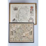
JOHANNES BLAEU (1650-1712), "Westmoria" , hand coloured engraved map with figural title cartouche,
JOHANNES BLAEU (1650-1712), "Westmoria" , hand coloured engraved map with figural title cartouche, similar scale, royal coat of arms and armorial ...
Lot 440
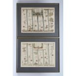
JOHN OGILBY (1600-1667), "London to Montgomery, North Wales", hand coloured engraved road map with
JOHN OGILBY (1600-1667), "London to Montgomery, North Wales", hand coloured engraved road map with figural title cartouche, 12 1/2" x 17 1/2", tog...
Lot 441
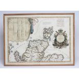
VINCENZO M. CORONELLI (1650-1718), "Scotia Parte Settentrionale", hand coloured engraved map (1690),
VINCENZO M. CORONELLI (1650-1718), "Scotia Parte Settentrionale", hand coloured engraved map (1690), with title cartouche and inset list of Scotti...