
Filtered by:
- Category
- List
- Grid
A subscription to the Price Guide is required to view results for auctions ten days or older. Click here for more information

1600, Map of Ireland by Matthias Quad (1557-1613) an engraved map of Ireland, Hiberniae, from his
1600, Map of Ireland by Matthias Quad (1557-1613) an engraved map of Ireland, Hiberniae, from his Geographisches Hand Buch (1600). German text. Pu...
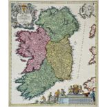
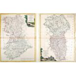
1676 Maps of the four Provinces of Ireland by Shenk and Valk, four hand coloured engraved maps,
1676 Maps of the four Provinces of Ireland by Shenk and Valk, four hand coloured engraved maps, Ulster, Mounster, Connaugt and Leinster, each plat...
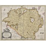
1720, Map of Ireland by Johann Baptiste Homann. A hand-coloured, engraved map of Ireland, 'Hiberniae
1720, Map of Ireland by Johann Baptiste Homann. A hand-coloured, engraved map of Ireland, 'Hiberniae Regnum tam in praecipuas, Ultoniae, Connaciae...
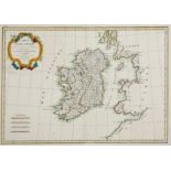
1771, Map of Ireland by Rigobert Bonne. A hand-coloured, engraved map of Ireland, Carte d'Irlande,
1771, Map of Ireland by Rigobert Bonne. A hand-coloured, engraved map of Ireland, Carte d'Irlande, 12½" x 17½" (32 x 44cm) mounted.
1778 A pair of hand-coloured, engraved maps of the Provinces of Connaught & Munster and Ulster &
1778 A pair of hand-coloured, engraved maps of the Provinces of Connaught & Munster and Ulster & Leinster by Antonio Zatta of Venice, each 16½" x ...
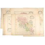
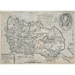
Monaghan, Five Barony Maps. Maps of the Baronies of Monaghan, Trough, Cremorne, Farney and Dartrey
Monaghan, Five Barony Maps. Maps of the Baronies of Monaghan, Trough, Cremorne, Farney and Dartrey from the General Survey of the County of Monagh...
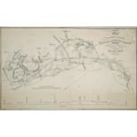
1840s Irish Railway map. An engraved map of "a Portion of the Projected Leinster & Munster Railway
1840s Irish Railway map. An engraved map of "a Portion of the Projected Leinster & Munster Railway Exhibiting the Main Trunk and the Extension as ...

Support the Treaty, two framed handbills, "Oaths! - The Oath under the Treaty is one of Allegience
Support the Treaty, two framed handbills, "Oaths! - The Oath under the Treaty is one of Allegience to Ireland....", 8¼" x 5½" (21 x 14cm) and "Sup...

Dawkins. Richard. The Greatest Show on Earth, signed first edition, Bantam, London, 2009, first UK
Dawkins. Richard. The Greatest Show on Earth, signed first edition, Bantam, London, 2009, first UK printing, signed to the title page.

Greene, Graham. 19 Stories, Heinemann, London, 1947, first edition, blue cloth with silver titles,
Greene, Graham. 19 Stories, Heinemann, London, 1947, first edition, blue cloth with silver titles, publisher's cream printed dustjacket. Some slig...